


Quite a change of scenery from Bryce, CapReef (as we came to call it) is noted for the 100 mile long Waterpocket Fold...a huge wrinkle in the earth's crust. A mere 65 million years ago, the uplifting of the Colorado Plateau created the Fold which is an eroded jumble of colorful cliffs, massive domes, soaring spires, twisted canyons, arches and natural bridges.
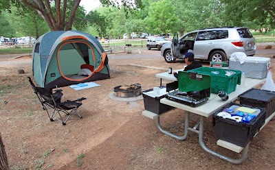
A far cry from the cozy digs at Bryce, we set up camp at the Fruita Campground at the north end of CapReef.

The Fruita Campground is nestled adjacent to the Gifford Homestead...an incredibly lush farm that was built in the early 1900's by Mormon settlers. In the early years, the Homesteaders of the Fruita Valley planted a variety of fruit trees to help sustain their existence in this mostly barren land. Apple, pear, cherry, peach and apricot trees abound over the 200 acre spread and those who camp here in CapReef are welcome to pick the fruits when in season. Unfortunately for us, a late spring has postponed the ripening of the apples and apricots...so we had to resort to buying Apple Pies at the Gifford House. What a delight!

Camp is established. Terry's exhausted from our Bryce Treks and decides to nap. My legs are itching to get out and hike so up the Cohab Canyon Trail I go - intended destination - Cassidy Arch - named after the infamous Butch Cassidy - who apparently frequented these parts.

Many of the Fold's "domes" are visible along this trail. Capitol Reef gets its name from two sources. The "Capitol" portion of the name comes from a large white dome-shaped rock that resembles the dome of the Capitol building in Washington D.C. The "Reef" refers to a barrier like a reef in the ocean. Since the Fold was a 100-mile long barrier to the pioneers of the West, the name Capitol Reef emerged.
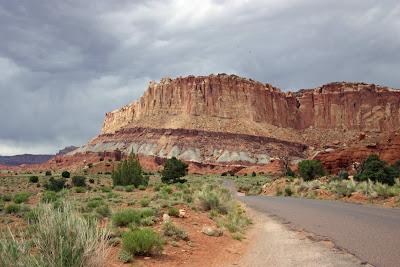
A zillion years ago this entire area lie beneath ancient seas. Layer upon layer of sedimentary stuff settled to the bottom of the seas. 65 million years ago, the seas dried up and the incredible geological forces of nature uplifted this region forming the Fold.

The carving knife that forged the Fruita Valley is the Fremont River. The Fremont has been the lifeblood of the Valley since the Fremont Culture Indians occupied the area dating back to 700 AD.
The Fremont River Trail runs parallel to the River for about 1/2 mile before climbing steeply up the side of Miner's Mountain. A great view of the Fruita Valley awaits those who make the Trek. What I've come to realize is most of the visitors to our National Parks are content hanging around camp. Very few of them seem to want to venture off onto the trails. (Which for me is quite OK) Ironically, most of the people I met on my hikes in Capitol Reef are from Germany. The Germans love to hike. I'm half German. Maybe that explains my deep down desire to lace up the boots and get dusty!

Erosion has created some really nifty natural resting spots!

Took this picture while walking from Camp Reefer to the Visitor Center.

Junior Rangers move over! The two newest Geezer Rangers are sworn in!

The Fremont Culture Indians were pretty good graffiti artists and tagged the cliffs with several petroglyphs which to this day puzzle archaeologists regarding their meaning! Heck, they were just drawing images of the spacemen who helped plant the orchards in Fruita Valley and build the cliff dwellings at Mesa Verde!

Joe Hickman (real name) was a local educator who labored to preserve Capitol Reef as a National Park. For his efforts, a 133 foot natural bridge was named after him. On the one mile trek to the Hickman Bridge, one is treated to the view above! What a perfect day for photos! It rained hard last night and today the blue skies are garnished with puffy cumulus clouds!

The culmination of the one-mile Trek up the Hickman Bridge Trail is none other than the Hickman Bridge! Long ago, this bridge was a narrow "fin" of sandstone. The persistent power of water and wind eroded away the bottom section of the fin leaving us with this fabulous view.

Happy CapReefers
Jimmy Buffett may have his Coral Reefers...but this Park now has a couple of very happy Capitol Reefers! A sleeper to begin with, Capitol Reef has become one of our favorite Parks. If you ever venture out to visit the Parks of Utah, be sure to include CapReef. Trek on friends!
Next up...Arches.
The rest of the story for those who want to explore the inner workings of Bink's Brain!
Capitol Reef National Park
June 11th. Up at 4:30 in the morning departing our Bryce Canyon Lodge Cabin heading for Capitol Reef National Park. This morn is dark, cold and cloudy. Car thermometer reading 43°. On the road for about a half hour when the need for the morning fix starts to kick in. Maybe the town of Tropic will have a coffee stop. It’s 6 am and the town of Tropic shows no signs of life. Perhaps Escalante. It’ll be close to 7 by the time we reach Escalante. No signs of life in Escalante either. Onward without caffeine. Ah ha! Kiva Koffeehouse ahead! I can smell the bittersweet aroma of freshly brewed coffee from here! But alas! Kiva doesn’t open until 8:30…an hour from now.
We continue our drive thru the Aquarius Plateau up and over a 9000’ summit draped with stands of Aspen and Pine. Deer grazing alongside the roadway everywhere. We reach the small town of Torrey at 8 and finally find a place to get a cup of Joe. Inside, there are at least 15 young men waiting in line for their coffee and egg sandwiches! Geez…what’s a grumpy old geezer gotta do to get a cup of coffee today? The owner of the coffee house takes pity on us and bypasses the hoard of youngsters and serves us up two Vente’s full of steamy hot heaven!
Hot coffee in hand, we now venture on into Capitol Reef in search of campsite #2. Site #39 it is! The Fruita Campground is situated on the western side of the Waterpocket Fold….the key attraction of this National Park.
We set up camp and Terry decides it is naptime. I, on the other hand, being the restless wanderer must hike! So off I go up the very step Cohab Canyon trail, camera in hand in search of the Cassidy Arch…named after Butch Cassidy who was supposed to have hung out in these parts. The guidebooks said something about the hike to the Arch being about a 3.5 mile round trip. Not a problem. I told Terry I’d be back in a couple of hours. Should be able to take in the Arch in that time frame.
An incredibly different hike compared to Angel’s landing or the Queen’s Garden. Trekking through the Fold means hiking on exposed rock most of the way. The only way to follow the “trail” is to keep your eyes peeled for the mini “hoodoo” Trail markers…stacks of 5 or 6 stones which show you the way. Lose the Hoodoos and you be lost!
The Trail guide lied. I’m about a mile into the hike when I come across the junction of the Cohab Trail and the Frying Pan Trail which leads to the Arch. Here, the sign tells me its another 3.5 miles to the Arch. 7 miles round trip? Hmmm. There ain’t no way this Trekker can do 7 more miles and get back to camp before Terry calls out the Posse to come find me.
Of course, the day I go hiking solo on the most primitive trail thus far on our Journey, I bring with me neither my GPS nor my SpottyMan! THIS is why those two devices were invented…and there they rest…back at camp with Terry!
Perhaps I ought to explain SpottyMan. As a going away “retirement” present, the FXcellent people at FX gave me a SPOT. (Satellite GPS Messenger) The “SpottyMan” is an English cartoon character superhero that our son Charlie used to watch when he was a kid. Thus our SPOT became “SpottyMan”!
When turned on, SpottyMan locates satellites in the sky and then is capable of transmitting several different types of messages. When you activate Spotty at home, you type up a couple of messages that you want him to send. The main message is an SMS text message to designated cell or email addresses stating: “We’re OK. Having a ball!” When this message is sent, the receiver gets the text message and the exact coordinates of our whereabouts. The receiving party can then go on to Google Maps and take a glance at exactly where the hell we are! This is really the only option you ever want to take when using the Spottyman as the other options are more for distress!
The second option is to send a message like…”we’re out of money…send some.” All this would do is worry the receiving party so we do not intend to ever transmit this choice.
The third option is to hit the Red Button. This in essence is a 911 call for help. You ONLY use this option if you are in dire straights. We never intend to activate the red button…but it is very comforting to know that in a genuine emergency…help would be on its way. The Spottyman has given Terry terrific peace of mind. And there I go off on my first solo hike…on the most primitive trail I’ve hiked in years…without the Spotted One!
Back to the hike – the early part of the Cohab Canyon Trail, rated “strenuous” as it rises rapidly up from the Campground, is littered with 1-2’ elliptical shaped black lava rocks resembling dinosaur eggs. The next portion of the trail is actually the burnt sienna sand wash where the rainwater escapes. Mostly, however, you walk atop of the smooth sandstone Fold following the manmade Hoodoo Trail Markers.
Back down from the Trek and at the base of the Fold sits the Fruita Campground which sits adjacent to the Fremont River. The Fremont Indian culture was the first known inhabitants of Fruita dating back to 700A.D. a twenty year drought ran them out of town in the 1300’s seeking wetter climes. Mormon settlers homesteaded this valley in the late 1800’s using the water from the Fremont River to plant orchards of apple, pears, cherries, and other edibles that the present day campers are welcomed to pick. We were a bit early in the season as there is no fruita for us to picka.
No fruit for dinner, so instead we dine on the best tasting Chili and Spaghetti noodles a couple of Geezer Campers could ever ask for. Along with the noodle concoction, we enjoy a Caesar Salad and a couple of cold Squatters Blonde Ales. We sit around the campfire listening to the wind howl overhead and the crackling of the pinion pine as the glow of our fire slowly dims. When was the last time you sat around the campfire next to your sweetie? It’s been decades since Terry and I have had this cozy experience and tonight will long be remembered!
June 12th. 9:30 am. Thunder echoes throughout the canyons and rain splatters down on our Hobitat. What an excellent way to spend the day. Teri and I sitting in our camp chairs inside Hob listening to the rain. Terry reads her book. I bang away on the keyboard writing about our Trek thru the Parks. Up at 6 this morning…before the rains begin. Brew up a pot of Snake River. Terry fries up the bacon and cooks up another batch of the most excellent hotcakes you could ever sink your camp-hungry teeth into. At this juncture, Terry announces…”there will be no hiking today!” We’ll see about that I silently say as another loud clasp of thunder shakes the Hob.
Now the rain is really coming down! Terry may be right. Today, we may spend entirely in the Hob. So, were the heck are we? Capitol Reef National Park featuring the Waterpocket Fold.
The Waterpocket Fold is a hundred mile long wrinkle in the earth’s crust caused by a violent uplifting when two tectonic plates did battle with one another some 70 million years ago. Imagine two giant slabs of earth colliding and the western slab, being the stronger of the two, forces the eastern slab skyward….some 30,000 feet! Time and erosion have whittled the Fold down exposing layer upon layer of colorful sandstone and limestone. The “waterpockets” are actually pockets of erosion in and amongst the sandstone slabs which capture vital rainwater whenever it rains. This is typically a very arid region (except for today!) and the early inhabitants of the area relied on the “waterpockets” to capture the rainwater!
The name “Capitol Reef” comes from the white “domes” along the top of the Fold which resemble the dome shaped Capitol building in Washington D.C. The “Reef” refers to the barrier this Fold created between the east and the west. Hence…Capitol Reef.
The rain stops. Terry suggests we go for a hike. Now that’s the spirit! We don our Hiking apparel and head up the Fremont River Trail…a mile long hike that runs adjacent to the Fremont River for about a half mile before rising steeply up the side of Miner’s Mountain.
Now there are literally hundreds of people camping in Fruita. And as is becoming typical on our trail treks, we encounter only 4 people. Two descending and two others who we pass on the hike up. Alone at the top of the mountain. What a view!
On our way down from the Fremont Trail we stop by the Gifford Homestead, the renovated and refurbished home of the original Mormon settlers. The Homestead sits just north of the Fruita Campground and is complete with barn, smokehouse and two-hole outhouse. Indoor plumbing and electricity were installed in 1948.
The last occupant was Dewey Gifford and family who lived in the home for 41 years (1928 to 1969) before selling the property to the Park Service. Since the Park Service took over, the kitchen has been converted into a Natural History Association sales outlet…featuring miniature Pies! Apple Pies, Berry Pies, Peach Pies. The best doggone Pie your five scoots can buy when you have just completed busting another trail! I just so happen to have ten scoots on me so dessert has been secured for this evening!
Darkness is settling in as we finish our Homestead Pies. The fire is dying down. Time to hit the REI Mummy sacks! We are serenaded by another bout of thunder, lightening and a gentle rain! Hey, what’s up with the rain? This is supposed to be an arid land with less than 10 inches of rain each year!
We awaken to a beautiful summer morning. Cool temperature and azure blue skies garnished with puffy white cumulus clouds…perfect for picture taking! Today, we visit the ancient petroglyphs of the Fremont Culture Indians. It amazes me that these drawings still exist 1300 years later…and that modern man hasn’t tagged over them with a can of Kryon spray paint.
These rock carvings depict trapezoidal shaped humanoids wearing elaborate headdresses mingling amongst snakes, lizards, birds, bighorn sheep, deer and other creatures. Archeologists to this day argue as to the meaning of the petroglyphs.
Next up, our hike to Hickman Bridge. Joseph Hickman, a local educator, fought hard to get Capitol Reef into the National Park system. His efforts, along with many others, finally paid off as CapReef officially became part of our Park System on December 18, 1971.
For his efforts, a 133-foot natural bridge was named after Joe. Standing 125 feet tall, Hickman Bridge was once a narrow sandstone fin that fell victim to the perpetual erosive power of water and wind…which eventually carved out the bottom portion of the rock. A great little hike!
Back to the Gifford Homestead for another round of Pie! Snuggle up once again in our Hob to get a good nite’s sleep before departing for our next destination…Arches National Park. What a Trek this has been!
I love the pictures in this post! Happy Fathers Day dad!
ReplyDeleteYes the pictures are so so so pretty!
ReplyDelete