After an exciting stay at the Kantishna Roadhouse in Denali, Terry and I ventured Southwest to Katmai National Park located on the peninsula of Alaska. From Anchorage, we flew to King Salmon aboard a 50 passenger Bombardier Jet. As there are no roads from King Salmon to Katmai, the next leg of our journey was via Float Plane...a first for both of us! The plane took off heading west from the Naknek River and landed on the Iliuk Arm of Naknek Lake.
Float Plane Service from King Salmon to Brooks
As with our Flightseeing excursion around Denali, Terry got the back seat in our Float Plane (N499K) and I sat next to the pilot. Taking off from and landing in water gave us quite a different flying experience!
FloatPlane Departure
Getting back to Anchorage meant we were treated to another Float Plane experience. This time, we got to fly in the Big Boy - a 9 passenger plane from Brooks Lake north to the Kulik Lodge. We were then escorted via a Ford Van to a dirt runway for our return flight back to Anchorage.
Brooks Lodge Digs
Our Cabin at Brooks Lodge came equipped with 2 bunk beds (it will sleep up to four) a sink, a shitter and a dinky shower. It also comes with a daily dose of bears walking just outside our porch!
Bear Jam Bridge
To get the best (and safest) view of the Brown Bears, you must cross this Bridge to gain access to the Viewing Platforms. The problem is the Bridge is closed frequently. If a Bear is 50 yards or closer to either of the Bridge's Entrances, the Rangers close the Bridge to all foot traffic.
It took us an hour and a half to get across the Bridge on our first attempt! A Momma Bear and her two cubs had taken up residency about 20 paces from the Eastern entrance. And they didn't budge for an hour!
Bear "jamming" Bridge Crossing
Here you see but a single Bear causing the Bridge to be closed. He appears to be swimming away from the Bridge...however, he's still within 50 yards. Therefore..."Bridge Closed!" While walking the grounds by the Ranger Station, the Cabins or the Main Lodge, guests would come within a few yards of the Bears. The Bears didn't seem to mind nor did they become hostile or agitated. So it seemed odd or perhaps a bit over cautious for the Rangers to close the Bridge when a single bear was within the 50 yard marker yet swimming away from the Bridge. I suppose they felt it is better for the visitors to be safe than mauled!
Brooks Falls - Popular Fishing Grounds
If you manage to get across the Bridge, you have three great Viewing Platform opportunities. The Lower River Platform sits at the west side of the Brooks River Bridge. The other two are about a mile and a half hike up to Brooks Falls (pictured above). In mid summer, Brooks Falls is teaming with Bears. That's because the Salmon are swimming upstream to spawn and the Bears literally grab them out of the sky as the fish attempt to leap from the lower falls to the upper reaches. But July also means that the Viewing Platforms are teaming with Tourists. We were told that it wasn't uncommon for people to have to wait up to three hours before they had access to the Platform. then, they were restricted to a one hour viewing. In September, we could have stayed on the Platform all day and not adversely impacted anybody.
In September, there are far fewer Bears fishing the Falls. We named the one at the far end of the Falls "Big Boy" as he was the AlphaBear and controlled this fishing hole. July and September are prime Bear Viewing months.
Atop Brooks Falls
To avoid any confrontation with Big Boy, this fellow chose to cross the river above the Fall line! the
Big Boy and his Fishing Hole
Big Boy sat patiently on his subsurface Bar Stool awaiting a tasty trout or salmon to happen close by. His head would then plunge into the bubbling water and up he'd come with fish wiggling frantically. In an hour, Big Boy would typically land four to six fish. The others we watched fishing in Big Boy's area were either poorer fisherbears or intimidated by the big guy.
Maned Bear moseying outside our Cabin
This mangy looking Bear hung out directly in front of our Cabin. We crossed his path on numerous occasions coming eye-to-eye with him one afternoon when returning from Brooks Falls.
Momma and Cub
Momma gave birth to three cubs earlier in the year. Unfortunately, she lost one of them in early August. I have come to understand that adult male bears frequently attack cubs knowing that Momma will not mate again until her cubs either reach the age of three and she's run them off or after the cubs have met a grizzly demise! (sorry for the pun)
This must be one tough Momma, as none of the males made even the slightest attempt to disturb her or the cubs during our stay.
Cubs cruising the Beach
The two surviving cubs were a joy to watch as they played, fished, swam and followed Mom everywhere. Mom will nurse these fellows for a couple of years. Then, she'll boot them out of the den as she goes in search for a new mate.
Snorkeling for Salmon
The River was full of Sockeye Salmon and Rainbow Trout. The Bears stick their heads in the water and "snorkel" for Salmon. The Sockeyes are easy to see. Their bodies had turned bright crimson. Their beaks dark green. They were at the end of their lifespan which means they trade in their handsome silver outfit for the Crimson and Green Halloween suit and then they die! Or become protein for the Grizzlies.
Sushi in the Morning
Bear eating a Sockeye. Notice the Crimson coloring. The bear will devour the entire fish. The head, the innards and the tail too! The Sockeye will spend several years swimming the ocean. When they reach the ages of four to six, the Sockeye will return to the rivers of their original birth to spawn. Some make it to the spawning grounds. Others end up as Bear Food!
Big Boy dueling with Fishing Competitor
Big Boy (the one on the left) took exception to another bear who wandered into his fishing hole. Big Boy judiciously ran the other bear out of town. Take note of the scars on the other Bear's butt. These were inflicted a couple of days earlier by Big Boy.
Falls Platform Viewing Station
With Big Boy in the background, we took this picture to illustrate just how close the viewing platform is to the Falls. Bears will fish within a few feet of the Platform. It would be nothing for them to gain access to the viewing towers if they desired a taste of human flesh. The gate separating the wild kingdom from the peeps on the platform is a mere 42" high. Thank goodness, there are plenty of fish...so they really have very little interest in us humans!
Also, please notice Terry's headgear! Our BugNets were perhaps the best $6 investment we have made along our Trek's. The mosquitoes were not a big issue, however, the gnats and flies were tenaciously attacking our faces! These nets are certainly not a fashion statement...however, they are extremely functional!
Bald Eagle swoops on Salmon
One of the highlights of our Bear Viewing happened at the Falls. We spotted this Bald Eagle perched atop the trees, scoping out the action below. Once he spied his breakfast, he swiftly swooped down and snagged a Sockeye.
Bus to 10,000 Smokes
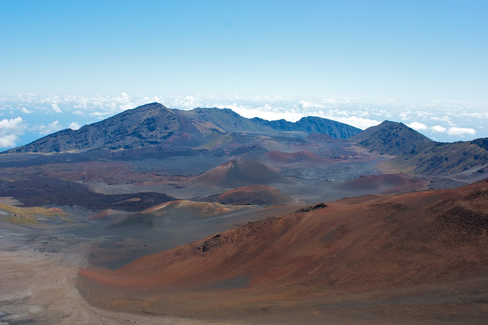
Although the Bear Viewing and Fishing are now the "main attractions" here at Katmai National Park, the reason this area is protected by the Park Service has to do with the "Valley of the 10,000 Smokes." On June 6, 1912, Novarupta erupted and still reigns as the most powerful volcano of the 20th century.
The volcanic blast was heard by residents of Juneau, AK...750 miles away. The magma ejected from Novarupa was 30 times greater than Mt. St. Helens. The ash cloud rose 20 miles high and by June 17th, the winds had carried it as far as Africa. When it was all said and down, the cloud circumnavigated the globe.
After the ash had settled, scientists, Geologists, National Geographic folks, thrill seekers and adventurers came to see the smoldering smokes of this volatile volcano. Thousands of steam jets vented across the vastValley, hence the name 10,000 Smokes. To preserve this region, Woodrow Wilson designated Katmai as a National Monument in 1918. The area reached National Park status in 1980.
Trail down into SmokesLand
During the two hour, 23-mile bus ride from Brooks Lodge to 10,000 Smokes, we encountered a wolf sighting, an owl and a bald eagle. The Bus crossed three shallow rivers (no bridges). The dirt road is narrow; however, there is only one vehicle on it - our Bus.
After lunch, we made the 2-mile hike down into the Valley floor. There were no more smokes! Only the leftover ash and such. After an hour of experiencing the rivers, the laval flows and the walls of ash, we made the 800 foot ascent back to the bus for the ride back to Brooks Lodge.
You may wonder how a bus made it to Katmai. It was manufactured in the States. Driven from Ohio to the west coast. Then barged up to Alaska. In fact, the only road in Katmai was built to accommodate visits to the Smokes.
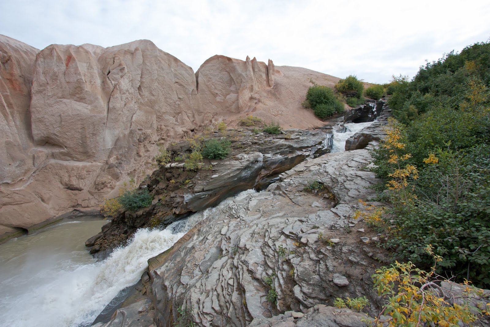
Smokes Falls
The ejecta from Novarupta blanketed the Valley floor with over 600 hundred of feet of ash and magma. Three rivers carve their way thru the valley exposing the sandstone colored compressed ash.
Smokes Walls
The the upper and lower Lethe River has carved its way thru the ash exposing spectacular walls of colorful ash.
Smokes River
The 10,000 Smokes excursion is worth the Bus ride. This region is otherworldly and provides the visitor an intriguing look at the awesome forces of nature.